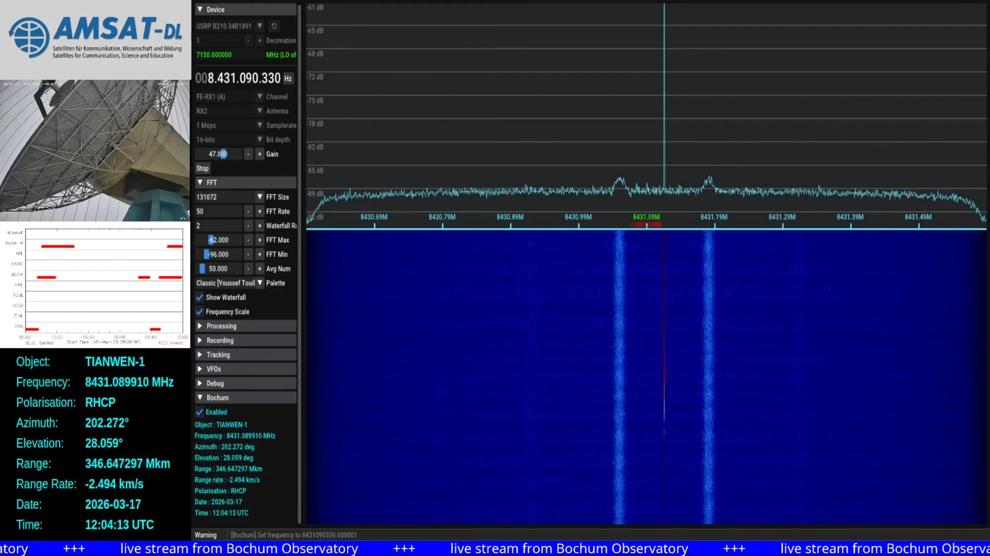
The signal strength looks completely normal, as evidenced by the spectrum plot shared in the announcement.
Screenshot of Tianwen-1 reception in Bochum shared by AMSAT-DL
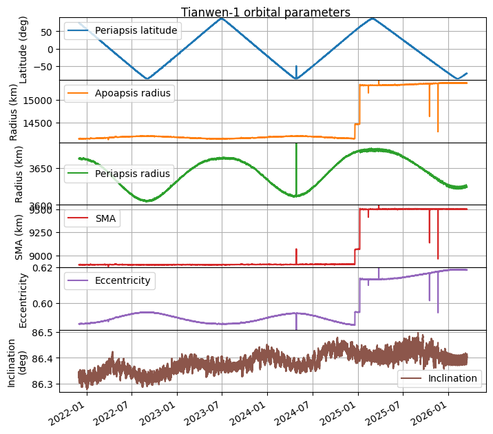
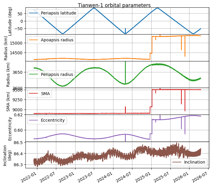
Telemetry containing state vectors was decoded between 2026-03-17 11:34 and 14:16 UTC. I have updated my plot of orbital parameters to include this new information. The period between 2025-12-23 and 2026-03-17 corresponds to a propagation with GMAT of the last telemetry received in 2025. The end of the plot corresponds to the telemetry received in 2026-03-17.
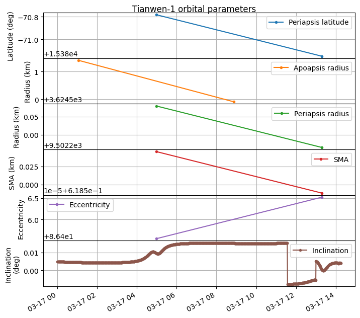
We can see that the orbit has remained the same, and there have been no manoeuvres during this period. A zoomed in version to the end of the plot shows that there is basically no jump in the orbital parameters. There is a tiny jump in the inclination as the new telemetry is received, but that is all.
So far the reasons why Tianwen-1 has apparently not transmitted telemetry to Earth for almost 3 months remain unknown.
Yesterday, AMSAT-DLpublished the news that they have been unable to receive any signals from Tianwen-1 with the 20 m antenna in Bochum since 2025-12-23. As you may know if you have been following my posts about Tianwen-1, AMSAT-DL has been using this antenna to receive and decode telemetry from Tianwen-1 almost every day since the beginning of the mission in 2020-07-23. The news about the lack of signal detected from Tianwen-1 over the last few months were hardly a secret, because AMSAT-DL runs a livestream of the signals received with the Bochum antenna 24/7, so anyone could look at the livestream and realize that Tianwen-1 was being observed but no signal was visible on the spectrum. However, now that the public has been made well aware of this fact, I can make some more comments about it. There has been no public communication from the Chinese space program regarding this, so the fate of Tianwen-1 is currently unknown.
During December 2025 and January 2026, there was a Mars conjunction, which means that Mars goes behind the Sun as seen from Earth. Communications with Mars orbiters cannot happen during this period of time. For instance, this news piece hints at NASA Mars missions not having contact between 2025-12-29 and 2026-01-16, which corresponds to a Sun-Earth-Mars angle (elongation) of 3º on 2025-12-29 and 1.8º on 2026-01-16, with the minimum elongation achieved on 2026-01-09. Therefore, it was completely expected that we would lose Tianwen-1’s signal during the conjunction period. Because the communications link to Earth does not work, spacecraft will usually not point their high gain antennas to Earth and even stop transmitting during this period. However, we expected to see Tianwen-1 back again after the conjunction, and we never did.
I have been using the telemetry decoded by AMSAT-DL, which includes the spacecraft state vectors, to keep track of the spacecraft orbit. I have been posting updates about any change that happens. The last one was the apoapsis raise on 2025-01-08. The lack of signals from Tianwen-1 sparked internal discussion about whether the spacecraft might have intentionally reentered some time around the conjunction period as a way of terminating the mission without leaving orbital debris. To analyse whether this could be possible, I have updated my orbit analysis to account for all the telemetry that has been received so far, up to 2025-12-22, which is when the last telemetry was decoded.
The result can be seen in the figure below. We see the apoapsis raises that happened during the end of 2024 and beginning of 2025. After that there have been no manoeuvres.
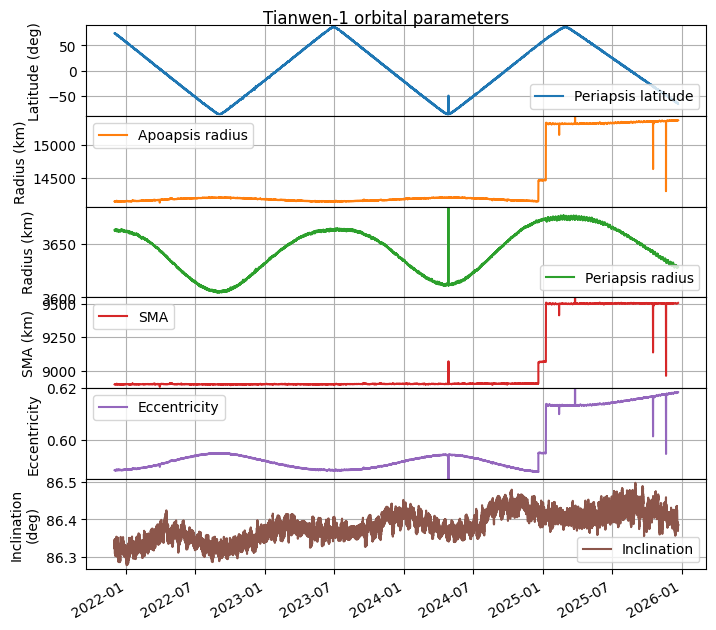
Since the plot above indicates that the periapsis radius would be going towards a minimum at the beginning of 2026 due to long-term periodic orbit perturbations, I propagated the last telemetry data we have forward with the goal of studying the impact of the larger apoapsis radius. The results are shown here. We note that the apoapsis radius minimum is now much higher than in the past, so the hypothesis of a reentry is unlikely unless a manoeuvre that we didn’t see in the telemetry has happened.
On March 22, CAMRAS performed a Venus radar experiment (or Earth-Venus-Earth bounce, as it is more commonly known in Amateur radio) in collaboration with Astropeiler Stockert, the Deep Space Exploration Society, and the Open Research Institute. The experiment was done in L-band, at 1299.5 MHz, using the 25 m Dwingeloo radiotelescope as transmitter and receiver and the Stockert 25 m telescope as a receiver. The experiment was done during the Venus conjunction, as this minimizes the distance between the Earth and Venus. The round-trip time to Venus was approximately 280 seconds. The radar waveform was a CW carrier with a duration of 278 seconds. It was transmitted a total of 4 times every 600 seconds. Thus each period was composed by:
278 second transmission
~2 second TX/RX guard time
278 second echo reception
~42 second wait
More transmissions were planned, including some spread-spectrum signals designed by the Open Research Institute. However, the transmitter started failing and they had to stop.
Update 2025-04-21: I have been informed that the spread-spectrum signal for this experiment was designed by CAMRAS. The waveform that the Open Research Institute is designing will potentially be used in future experiments.
In this post I will do my own analysis of the experiment. The goal is not to confirm the successful detection with an independent analysis, since I believe that the analysis published by CAMRAS is correct and leaves no doubt about this. It is to expand this analysis and to touch on other topics that this analysis has not covered:
Calculation of the Doppler. CAMRAS has published CSV files containing the expected Doppler at each receiver, but they have not published the code to calculate this. Here I will do all the relevant calculations with SPICE.
Doppler correction with the gr-satellites Doppler correction block, which performs linear interpolation of the Doppler frequency to calculate the frequency shift applied to each sample.
High-quality spectral analysis with a polyphase filterbank.
Try to estimate the Doppler spread and compare with some results in the literature.
Some weeks ago I reported about an apoapsis raise manoeuvre done by Tianwen-1, the Chinese Mars orbiter. This has now happened again. Using state vectors from the telemetry decoded with the 20 m antenna in Bochum observatory by AMSAT-DL, we have detected an apoapsis raise manoeuvre done on 2025-01-08. This new apoapsis raise is much larger than the previous one. I have done the same kind of calculations as in the previous post, and also corrected a bug in my Keplerian elements plots (the periapsis and apoapsis passings were being paired incorrectly, which caused the SMA and eccentricity not to change in the plots I did in the previous post).
For a long time, AMSAT-DL has been using the 20 meter antenna in Bochum observatory to receive some telemetry from Tianwen-1, the Chinese Mars orbiter, almost daily. Since the telemetry includes the spacecraft’s state vectors, we can use this to monitor the spacecraft’s orbit. In 8 November 2021, Tianwen-1 entered its remote sensing orbit. This is an elliptical orbit with a period approximately 2/7 Mars sidereal days plus 170 seconds. This causes a ground track that is almost repeating, but drifts slowly to cover all the surface area of the planet.
I have been posting yearly updates about Tianwen-1’s orbit, the last of them this summer. In these updates, we can see that no manoeuvres have happened, and the changes in the Keplerian elements correspond to orbital perturbations caused by external forces. The orbit is in fact designed to cause the latitude of the periapsis to precess. In this way, all the surface of Mars can be scanned from low altitude.
Now we have some news. In the telemetry of the last few days we have detected that Tianwen-1 has raised its apoapsis radius from about 14134 km to 14489 km. All the data we have indicates that a propulsive burn has happened recently. In this post I give the details about this apoapsis raise manoeuvre.
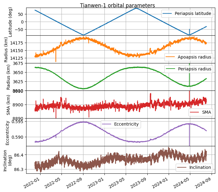
Last year I wrote a post on July 23, which is the anniversary of Tiawen-1‘s launch. The post was essentially an updated plot of the orbital parameters of Tianwen-1’s remote sensing orbit. As I explained in that post, AMSAT-DL is using the 20 meter antenna in Bochum observatory to receive telemetry from Tianwen-1 almost every day (this can be followed in the YouTube livestream). Since Tianwen-1 includes its state vector (position and velocity with respect to Mars) in its telemetry, this allows us to monitor its orbit, which is of interest because no other public detailed information is available.
This year I completely forgot to do the same again for July 23, but I have remembered now. Here is the updated plot of the orbital parameters of Tianwen-1 since 8 November 2021, when the remote sensing orbit began. The plot includes data until 2 August 2024. During most of August, AMSAT-DL is not tracking Tianwen-1, since Mars has a very similar right ascension to STEREO-A, and tracking STEREO-A has priority. Tracking of Tianwen-1 will resume as the two objects drift apart in right ascension.
All the changes in the orbital parameters are due to perturbations by the Sun’s gravity and the oblateness of Mars, since as far as I know there have been no manoeuvres in this orbit. The main change in orbital parameters is a steady change in the latitude of the periapsis. The orbit is designed on purpose to exploit this effect. Over time, all the surface of Mars can be observed from a low altitude. This perturbation is related to a change in eccentricity, which is minimal when the periapsis is over the north pole and maximal when the periapsis is over the south pole.
Now it is quite apparent that there is also a slow but steady increase in inclination. This was not so evident last year, due to a sinusoidal perturbation that is also present, but now it is clear that the inclination has increased by about 0.05 deg since November 2021. It seems that this increase in inclination is related to a small increase in the semi-major axis.
Today is the third anniversary of Tianwen-1, which was launched in 23 July 2020. During the first year of the mission I was tracking it with great detail and writing a lot of posts. A fundamental part of this work was the help of AMSAT-DL. Using its 20 metre antenna in Bochum, they tracked the spacecraft, decoded telemetry and provided live coverage of many of the key mission events in their Youtube livestream. At some point the reception of Tianwen-1’s telemetry at Bochum got completely automated, as we described in a paper in the GNU Radio Conference 2021 proceedings.
To this date, the reception continues in Bochum almost every day, when the dish is not busy with other tasks such as tracking STEREO-A. This means that we get good coverage of the spacecraft orbital data, via the state vectors transmitted in its telemetry.
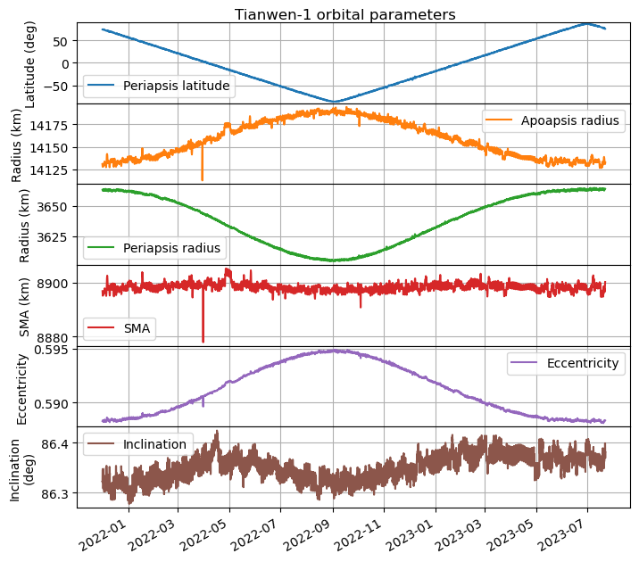
To celebrate the anniversary, I have updated my plot of the orbital parameters, which I made back in March 2022. The plot covers all the remote sensing orbit, from when it started on 8 November 2021, until the present day. To my knowledge, no manoeuvres have happened in this time (perhaps small station-keeping burns would be unnoticed without more careful analysis), so the changes in the orbit are just due to perturbations by forces such as the Sun’s gravity and the oblateness of Mars.
The updated plot can be seen below. We see that the periapsis latitude changes at a steady rate of 0.598 deg/day. The remote sensing orbit was designed so that the periapsis precessed in this way, which allows the spacecraft to cover all the surface of Mars from a low altitude in 301 days. The surface has now been covered twice, since the periapsis has moved from near the north pole to the south pole and back again to the north pole.
There is also an interesting change in eccentricity, which seems to be correlated with the latitude of the periapsis. The eccentricity is largest when the periapsis is over the south pole. In this case, the altitude of the periapsis decreases by 60 km, compared to when the periapsis is over the north pole. The inclination has remained mostly steady, although there seems to be a small perturbation with an amplitude of 0.1 deg.
The updated Jupyter notebook in which this plot was made can be found here.
On June 2, ESA celebrated the 20th anniversary of the launch of Mars Express (MEX) by livestreaming images of Mars from the VMC camera in a Youtube livestream. They set things up so that an image was taken by the camera approximately every 50 seconds, downlinked in the X-band telemetry to the Cebreros groundstation, which was tracking the spacecraft, and then sent to the Youtube. The total latency, according to the image timestamps that were shown in Youtube was around 17 minutes, which is quite good, since most of that latency was the 16 minutes and 45 seconds of one-way light time from Mars to Earth.
The livestream was accompanied by commentary from Simon Wood and Jorge Hernández Bernal. One of the things that got my attention during the livestream was the mention that to make the livestream work, the VMC camera should be pointing to Mars and the high-gain antenna should be pointing to Earth. This could only be done during part of Mars Express orbit, and in fact reduced the amount of sunlight hitting the solar panels, so it could not be done for too long.
This gave me the idea to use the Mars Express SPICE kernels to understand better how the geometry looked like. This is also a good excuse to show how to use SPICE.
In a previous post, I showed my orbit determination experiments of the GEO satellite Es’hail 2 using the beacons transmitted from Bochum (Germany) through the QO-100 amateur radio transponder on-board this satellite. By measuring the phase difference of the BPSK and 8APSK beacons, which are spaced apart by 245 kHz in the transponder, we can compute the three-way range-rate between the transmitter at Bochum and my receiver in Spain. This data can then be used for orbit determination with GMAT.
I have continued collection more data for these experiments, so this post is an update on the results.