Mars 2020, NASA’s latest mission to Mars, was launched a couple weeks ago. However, with all the Tianwen-1 work down the pipeline, until now I haven’t had time to dedicate an appropriate post to this mission (though I showed some sneak peek on Twitter). This mission consists of a rover and helicopter (a real novelty in space exploration). Both were launched with the cruise stage and the entry, descent and landing system on July 30 from Cape Canaveral, an are currently on their transfer orbit to Mars, as Tianwen-1 and Emirates Mars Mission.
In this post I will be working with some recordings made by AMSAT-DL using the 20m radio telescope at Bochum’s observatory. These feature the low rate safe mode telemetry, which was very strong and caused some anecdotes as it saturated some NASA DSN receivers, and the nominal 10kbps telemetry signal that was switched on later. Here I will describe the modulation and coding, giving GNU Radio decoders, and also take a look at the data. r00t.cz has also written a post where he shows similar information.
In this post I analyse part of the telemetry transmitted by Tianwen-1 over high-speed data done on 2020-08-03. The decoded frames were kindly provided by Paul Marsh M0EYT. r00t.cz has made an analysis of this data in his Tianwen-1 page, which also includes some more information not shown here. This telemetry contains a full playback of some channels spanning 2020-07-25 to 2020-08-02, including gyroscope data, as described in this post.
In a previous post I talked about how the high data rate signal of Tianwen-1 can be used to replay recorded telemetry. I did an analysis of the telemetry transmitted over the high speed data signal on 2020-07-30 and showed how to interpret the ADCS data, but left the detailed description of the modulation and coding for a future post.
Here I will talk about the modulation and coding, and how the signal switches from the ordinary low rate telemetry to the high speed signal. I also give GNU Radio decoder flowgraphs, tianwen1_hsd.grc, which works with the 8192 bit frames, and tianwen1_hsd_shortframes.grc, which works with the 2048 bit short frames.
Yesterday I reported about Tianwen-1’s first trajectory correction manoeuvre, TCM-1. In that post I commented the possibility that the updated state vectors that we saw on the telemetry after TCM-1 might come from a prediction or planning rather than take into account the actual performance of the burn.
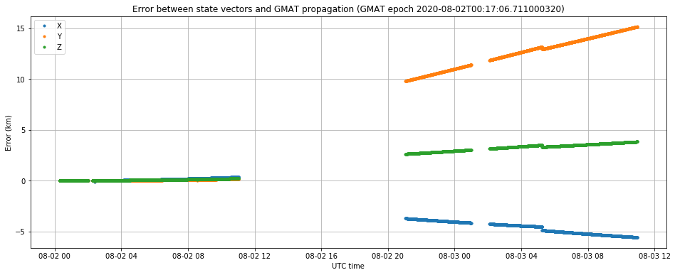
The figure below shows the error between the state vectors collected after TCM-1 over the last two days, and a trajectory propagated in GMAT, using the following state vector, which is one of the first received after TCM-1.
We see that on the UTC night between August 1 and 2 the state vectors deviate very little from the GMAT trajectory. However, on the UTC night between August 2 and 3 we see a slightly different trajectory in the state vectors. We have no data in between, as the spacecraft is not visible in Europe, so we don’t know the precise moment of change. The gap in telemetry around 2020-08-03 00:45 UTC is due to a transmission of high-speed data.
It seems reasonable to think that after TCM-1 the Chinese DSN performed precise ranging of the spacecraft to determine the new orbit accurately and then uploaded a correction to the state vectors on-board Tianwen-1.
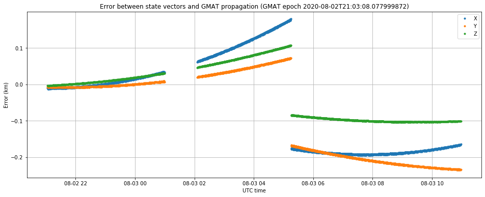
The state vectors from last night all describe the same trajectory, as shown in the plot below which uses
to propagate a trajectory in GMAT. There is a small jump of a few hundred meters at some point. We usually see one or two these jumps per day, but we don’t understand well why they happen.
The trajectory according to the state vectors from 00:17:06 and from 21:03:08 are very similar. For example, at the closest approach to Mars they only differ in 1197km. For comparison, the difference between the new trajectory and the pre–TCM-1 trajectory is 126529km (again, at the closest approach to Mars).
Since Tianwen-1 transmits its own real time orbit state vectors in the telemetry, by comparing the vectors transmitted before and after TCM-1, and also by studying the Doppler observed by groundstations on Earth, we can learn more about the manoeuvre.
On the Beijing time morning of 2020-07-30, Tianwen-1 did something. Paul Marsh M0EYTreports that the probe first switched from the high gain antenna to the low gain antenna, then returned to the high gain antenna, and then switched to a high-speed data mode, finally coming back to the usual 16384baud telemetry.
r00t.cz has already analysed the telemetry data collected during this event. He reports that the high speed data was a replay of the telemetry produced during the period when the low gain antenna was used. He shows some interesting behaviour on APIDs 1280, 1281 and 1282 (see my previous post for a description of these during nominal operation). These seem to contain ADCS data.
This event was followed with some expectation by the Amateur deep space tracking community, since according to this paper Tianwen-1 would make the first correction manoeuvre (TCM-1) early on in the mission (day 9 is stated in the paper). However, by now it is clear that a true correction manoeuvre didn’t happen, since no significant change has been seen in the trajectory described by the state vectors transmitted in the spacecraft’s telemetry. However, this event might have been a very small thruster firing, in order to test the propulsion in preparation for the true TCM-1.
In this post, I look at the data during the high speed replay, following the same approach as in the previous post. With this data, I reach a definite conclusion of what happened during this event (I won’t spoil the mystery by stating it in advance). The description of the modulation and coding used by the high speed data will come in a later post.
The Jupyter notebook for the calculations in this post can be found here.
This is a follow-up to my previous post, where I explained the modulation and coding of Tianwen-1’s telemetry. In this post I will explain the framing structures and the data contained in the telemetry (though we only understand a few of the telemetry channels). Most of what I’m going to explain here was found first by r00t.cz and is already presented in his Tianwen-1 page. In this post I’ll try to give a bit more detail (especially for those not so familiar with the CCSDS protocols) and some Python code for those interested in digging into the data.
In my previous post I explained how our problems using the orbit state vectors transmitted in the telemetry of Tianwen-1 were caused by an incorrect interpretation of the timestamps attached to these vectors. The timestamp is a 32 bit counter with a 100us resolution, but the difficulty is that the epoch of this counter is not known. It seems that the epoch is around 2020-07-23 00:00 UTC, which is the day of launch, but not quite because approximately 57 minutes need to be subtracted from the epoch.
In my post I used some sort of experimental procedure to determine the correction that needs to be subtracted from the timestamp, and I obtained 3400.2 seconds, which I believe should be accurate to within a few seconds.
However, I found this correction somewhat unsatisfactory, as I wasn’t able to explain where it comes from. Now I think I have found a reasonable explanation.
Yesterday I published a post explaining how Tianwen-1 is transmitting real time state vectors for its own orbit in its telemetry and how we’ve used those to propagate its orbit and track the spacecraft with the Bochum observatory 20m dish. However, there seemed to be some problem in the way we were interpreting the state vectors, since the ephemerides derived from these had a pointing error of a few degrees when compared with observations from Bochum and other smaller Amateur stations.
As of writing that post, I believe I have found the problem. It has to do with the way that the timestamps from the state vectors are interpreted. After correcting this problem I am getting an orbit that matches the observations well. Here I explain this problem and show some more details about the corrected ephemerides.