In a previous post, I looked at the telemetry packets transmitted by the satellite 3CAT-2. This satellite transmits 9600bps AX.25 BPSK packets in the Amateur 2m band. As far as I know, it is the only satellite that transmits fast BPSK without any form of forward error correction. LilacSat-2 uses a concatenated code with a (7, 1/2) convolutional inner code and a (255, 223) Reed-Solomon outer code. The remaining BPSK satellites transmit at 1200bps, either using AX.25 without FEC (the QB50p satellites, for instance), or with strong FEC (Funcube, for example). Therefore, I remark that 3CAT-2’s packets will be a bit difficult to decode without errors. But how difficult? Here I look at how to use the theory to calculate this, without resorting to simulations.
Tag: vhf & uhf
Decoding packets from 3CAT2
On 15th August, a Chinese CZ-2D rocket launched three satellites from Juiuquan (Mongolia). The main payload was the Chinese satellite QSS, designed to do some experiments in quantum communications and entanglement. As anything that has the word quantum on it, this satellite even made it to the mainstream news in Spain. The rocket also launched Lixing 1, another Chinese satellite which will research the upper atmosphere, and 3CAT2, from the Universidad Politècnica de Catalunya (Spain).
3CAT2’s main payload is a GNSS reflectrometer designed to measure the altitude of the Earth and map the oceans. This means that it uses reflections of satellite navigation signals off the surface of the earth and sea to perform mapping. It will mainly use the L1 and L2 signals from GPS, but it can also work with Galileo, GLONASS and BeiDou signals. It also carries a prototype of a magnetometer designed for the eLISA project. This project consists in setting up a laser interferometer in space to observe gravity waves. It is roughly the same as the Earth-based LIGO, that recently confirmed the first detections of gravity waves. However, since eLISA will be in space, its laser arms will much longer than LIGO’s. This permits to study much lower frequencies than it’s possible Earth-based interferometers.
3CAT2 has a downlink in the Amateur 2m band, at 145.970MHz, and transmits 9600bps BPSK. It also has a faster BPSK downlink in the S-band, presumably at 2401MHz (inside the Amateur 13cm band). The days following 3CAT2’s launch I tried to receive its VHF signal, without any luck. I have been in contact with other Amateurs who also listened and didn’t hear anything.
This morning, I’ve received email from Scott K4KDR telling me that he has heard the satellite for the first time and he has managed to do a recording, but he is unable to decode the data.
We where unsure about which encoding that 3CAT2 is using. It could be AX.25, or some custom protocol using FEC. As far as I know, the only other satellite that transmits 9k6 BPSK in the Amateur bands is LilacSat-2, which uses strong FEC. Nevertheless, I’ve taken a good look at Scott’s recording and I’ve been able to decode one packet. This is, as far as I’m aware, the first decoding of 3CAT2 by an Amateur operator.
Recovering an RS92-SGP radiosonde
A few days ago, I talked about the radiosondes that are launched every 12 hours from Madrid-Barajas Airport. Yesterday, I went with my mother on a trip to try to recover the radiosonde that was launched at 11:00UTC. This radiosonde managed to ascend to 31000m before bursting. This is quite high for a radiosonde of this kind, as they usually burst between 24000 and 28000m.
We left home at 13:00UTC, so the radiosonde was quite far from us by that time. The last telemetry we managed to decode was when the radiosonde was 3800m high and on its way down. It was flying over Sacedón, in Guadalajara, and slowly drifting eastwards along the road. We were still on our way to Guadalajara, more than 40km away.
Receiving the Vaisala RS92-SGP radiosonde launched from Madrid-Barajas
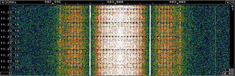
Each day, at 01:00UTC and 11:00UTC a Vaisala RS92-SGP radiosonde is launched from Madrid-Barajas airport. This is a small electronics package tied to a helium balloon that ascends up to between 24 and 28km high before bursting and descending on parachute. It is designed to measure atmospheric parameters on its way up. It includes temperature, pressure and humidity sensors, as well as a GPS receiver. The launch on Wednesdays at 11:00UTC also includes a plug-in ozone sensor (which is a much larger and more expensive package). The data is transmitted at 403MHz using Manchester-encoded 4800bps GMSK and protected using Reed-Solomon. You can find more information about the RS92-SGP model in its technical datasheet and about the launches at Madrid-Barajas and other launches in Spain in the Spanish AIP Section 5.3 (other activities of a dangerous nature). Also, there is somebody who feeds the radiosonde data into the APRS network using SM2APRS, so you can track the launches by following OKER-11 on aprs.fi.
Usually, the Sondemonitor software is used to receive and plot the parameters measured by the radiosonde and track the GPS data. Of course, this program is very nice and complete, but it is shareware, costs 25€ and runs only in Windows. I wanted to try if it is possible to track the GPS data in Linux using free software.
Concurso Nacional V-UHF

Today I’ve hiked up with my father to Siete Picos, SOTA summit EA1/SG-005 (2138m), to participate in this month’s national V-UHF contest. We arrived and set up around 07:30UTC and worked until 11:30UTC, where activity became low, as most possible contacts were already done and people started to leave in order to prepare lunch. The equipment was a Yaesu FT-817ND and an Arrow yagi antenna (3 elements in 144MHz and 7 elements in 432MHz).
Below is the map of stations worked. My position is in red, stations worked both in 144MHz and 432MHz are in green and stations worked only in 144MHz are in blue. The black station is the odd one that I could only work in 432MHz. This can happen if you catch them first in 432MHz, then a big mess with several stations arises and you’re unable to tell them to change to 144MHz to make the contact and decide that you’ll catch them in 144MHz later, but you don’t manage to find them later.
Concurso Atlántico V-UHF

Today, I’ve participated in this month’s national V-UHF from Cerro de San Pedro, SOTA summit EA4/MD-020 (1425m). I arrived the summit a bit before 10:00UTC and worked until the end of the contest (14:00UTC). The equipment was the usual: a Yaesu FT-817ND and an Arrow satellite yagi antenna (3 elements in 144MHz and 7 elements in 432MHz).
Find below the map of stations worked. My location is in red, stations worked both in 144MHz and 432MHz are in green and stations worked only in 144MHz are in blue.
Concurso Sant-Sadurní V-UHF

Last Sunday, I hiked up Cerro de San Pedro, SOTA summit EA4/MD-020 (1425m) to work in this month’s national V-UHF contest. I was on the summit for 4 hours, from 7:00UTC to 11:00UTC, and I managed to work quite a few stations. As always, I used my portable QRP station consisting of a Yaesu FT-817ND and an Arrow satellite yagi antenna (3 elements in 144MHz and 7 elements in 432MHz).
In the map of stations worked, my position is in red, stations worked both in 144MHz and 432MHz are in green and stations worked only in 144MHz are in blue.
Concurso Segovia V-UHF

This weekend has being very rainy, so I haven’t been able to participate in the national V-UHF contest with my usual portable setup. Instead, I have driven to the countryside just outside town and used the mobile antenna on my car to work in the contest from inside the car. This antenna is a 50cm vertical whip which is magnetically mounted on the roof of the car. Of course, due to the low gain and polarization mismatch, I am only able to work some local contacts with this antenna. In this way, I have been able to have a couple hours of fun this morning without getting wet.
As always, the map of stations worked below. My position is in red. Stations in blue where worked only in 144MHz. Stations in green where worked both in 144MHz and 432MHz.
First signals from AAUSAT-4

Today I woke up early to receive the signals from AAUSAT-4 as it passed over Spain for the first time. This satellite was launched from Kourou yesterday at 21:02UTC into a Sun-synchronous orbit. The main payload for the launch was Sentinel-1B, a 5GHz Synthetic Aperture Radar satellite from the Copernicus project of the ESA. The remaining satellites that were launched by the Soyuz rocket were Microscope, from the French CNES, designed to test Einstein’s equivalence principle and the three cubesats in the Fly You Satellite! program: OUFTI-1, from the University of Liège, which carries a D-STAR amateur radio transponder, e-st@r-II, from the University of Torino, and AAUSAT-4, from the University of Aalborg, which carries an AIS receiver. Since the launch was into a polar orbit, the first pass of the Fly Your Satellite! cubesats over Spain was at 05:42UTC today.
Concurso Costa del Sol V-UHF 2016

Yesterday, my father and I hiked to Cerro de San Pedro, SOTA summit EA4/MD-020 (1425m), to work QRP in this month’s national V-UHF contest: Concurso Costa del Sol. Since the forecast for Sunday was rainy, I decided to go up on Saturday’s afternoon. The summit is a short hike from a nearby road. We arrived to the summit around 14:25UTC, so I could work in the contest for a bit more than two hours until we started packing at 17:00UTC before it got too dark.
Activity seemed a little low, although this is not surprising, given that the national RTTY contest was also running at the same time. I also get the impression that there is more activity on Sunday mornings. Nevertheless, my results have been better than in March’s contest. I did fewer QSOs, but got more points and worked more DX. In fact, I could work almost everybody I heard. In the map below, as always, my location is marked in red, the stations in blue are those worked only in 144MHz and the ones in green where worked both in 144MHz and 432MHz.